Urged by King Ferdinand to search for undiscovered islands northwest of Hispaniola, Juan Ponce de Léon set out from Puerto Rico at his own expense with three ships and some two hundred men on March 4, 1513. As the first Spanish explorer after Columbus to strike out boldly into the unknown, what Ponce de Léon and his crew were about to discover would not disappoint. On April 2, they sighted an unfamiliar landmass, which their leader named La Florida. After spending several days in the area of their Florida landing, the ships turned south for further exploration along the coast. Then, on April 8, the crew experienced “a current such that, although they had great wind, they could not proceed forward, but backward and it seemed that they were proceeding well; and at the end it was known that the current was more powerful than the wind.” The smallest ship, the San Cristobal, was carried out of sight and lost for two days. The Spaniards had discovered the Gulf Stream.
This natural phenomenon, which can be described as “a series of overlapping currents arranged somewhat like the shingles on a roof,” has aided transatlantic voyages between old world and new for centuries. Measured in volume per second, the Gulf Stream moves about 1,000 times faster than does the Mississippi River. Within just a few years of the 1513 discovery, there exists documented evidence that Spaniards were using the Gulf Stream and its powerful boost to maximum effect with their eastbound trade routes. Why, then, did it take over 250 years for the first dedicated chart of the Gulf Stream to arise in 1769?

Detail of Kircher’s Mundus subterraneous
Charts depicting currents and their flow had existed long before 1769. Between 1668 and 1678, German Jesuit scholar Athanasius Kircher in his Mundus subterraneous published a rough sketch of a northerly flowing current in the Atlantic Ocean. H. A. Marmer, in his seminal work on the Gulf Stream in 1929, notes that during this period the mariner and especially the whaler would have been well acquainted with the Gulf Stream and its effects, but much of this information “was kept as a professional secret.” Rather than be recorded in journals, practical knowledge was handed down by trusted apprenticeship and by word of mouth. With the emergence of competing hegemonic European powers in a new transatlantic world, every advantage counted.
Despite the competitive secrecy established from 1513 on, a confluence of immediate and gradual events shaped a course that would empower the inquisitive mind of Benjamin Franklin to publish the first true chart of the Gulf Stream in 1769. His motive in doing so demonstrated a desire for peace and harmony between England and her colonies at a time when tensions between the two were escalating to the point of rebellion. The transatlantic context in which Franklin produced his Gulf Stream chart will show us just how dedicated this Founding Father was to preserving the unity of the British Empire prior to the Revolution.
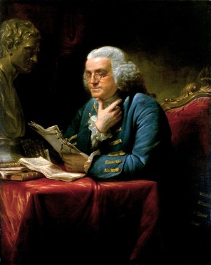
Franklin in London, 1767
Serving in London as Deputy Postmaster General for the American colonies, Franklin was consulted on the question of why it took mail packet ships two weeks longer to sail from England to New England than the merchant ships. In October 1768, Franklin raised this issue with his cousin, Nantucket whaler Timothy Folger. Captain Folger informed Franklin that he and his fellow whalers were “well acquainted with the stream because in our pursuit of whales, which keep to the sides of it but are not met within it, we run along the side and frequently cross it to change our side.” The captain added that often in crossing the stream, he would encounter British packet ships who “were in the middle of it and stemming it,” and would advise them on how to cross it, but “they were too wise to be councelled [sic] by simple American fishermen.”
Franklin had Captain Folger sketch the Gulf Stream on a chart and add written notes on how to avoid it when traveling westward. He then had the chart engraved either in 1769 or 1770 by Mount and Page in London for use in speeding packet ship voyages to New York. Franklin, in a letter to David Le Roy in 1785, remarked that copies of the chart “were sent down to Falmouth for the captains of the packets, who slighted in however.” As tensions mounted between England and her colonies in the 1770s and Franklin realized unity was no longer an option, it is likely he suppressed the chart to prevent its use by the British Navy. This could perhaps explain why a copy of the chart remained lost for over 200 years until Philip L. Richardson discovered two prints of it in 1978 at the Bibliothèque nationale de France in Paris.
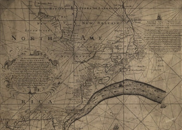
The Franklin-Folger chart, 1769-1770
Until a break with the crown became imminent, Franklin desired nothing more than to maintain unity between England and her American colonies. Hindsight tells us that slow communication was one of, if not the supreme catalyst in escalating tensions between the two. Having spent, in total, approximately two years of his life traveling on the Atlantic, this fact would not have been lost on Franklin. While he believed in the importance of living with virtue, Franklin’s central aim was to live usefully. With the chart, he sought to ensure greater speed of trade between England and her American colonies. Whether from a political, economic, or scientific standpoint, creating the Franklin-Folger chart was certainly useful. His intent for its use was one way in which he sought to reduce conflict, mitigate tension, and reconcile king and colony. The hostile reaction he received from British captains now seems indicative of his lack of success in doing so.
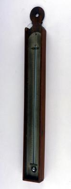
Thermometer purchased by Franklin in London, ca. 1760
If this transatlantic context illustrates the pragmatic ethos of Benjamin Franklin, putting his Gulf Stream chart in a colonial context will bring forth his pride. In 1775, Franklin made the first of three water temperature observations during Atlantic crossings. These observations, he believed, would help seafarers positively know when they entered or left the Gulf Stream. In a letter to his old friend, Dr. Joseph Priestley, dated May 16, 1775, Franklin noted, “You will have heard, before this reaches you, of a march stolen by the Regulars into the country by night, and of their expedition back again. They have retreated twenty miles in six hours…. In coming over, I made a valuable philosophical discovery, which I shall communicate to you when I get a little time.” What could possibly explain Franklin weighing his “philosophical discovery” of water temperature observations in the Gulf Stream on equal footing as the events of Lexington and Concord? And how are these events related?
Historians John Clive and Bernard Bailyn contend that in the eighteenth century the American colonies, similar to Scotland, experienced “a blossoming worthy of the designation ‘golden age.’” Burgeoning sentiments of superiority coming from London became manifest in the colonies in the years following the French and Indian War. Royal officials placed in charge of governing affairs in the colonies brought with them not only magisterial duties but also the tastes and culture of a more refined England. These “agents of imperialism” reminded colonists that they existed on the periphery of a greater world, whose common center was London. An official, royal presence emphasized the provincial character of life in America. This provincialization of American towns, and the sense of inferiority it created, fostered in the intellectual middle class a “creative imagination” and “compensatory local pride” that would ultimately come to fruition politically with the American Revolution. Much like Thomas Jefferson’s diverse reflections on natural history, economy, and state in his Notes on the State of Virginia (1785), Franklin’s seafaring investigations of the Gulf Stream represent one of the many ways in which he contributed to an American Enlightenment. For Franklin, the events of Lexington and Concord and his “philosophical discovery” of Gulf Stream temperatures were both intertwined in the rapidly deteriorating rapport between king and colony.
Subsequent drafts of the 1769-1770 Franklin-Folger chart were printed in France in 1778 and the United States in 1786, ensuring his observations did not go unnoticed. Nevertheless, it is the original chart that remained hidden until 1978 that reveals the most about Franklin’s psyche in the midst of a growing revolutionary rift between two places he held dearly. It is quite possible Franklin considered his observations of the Gulf Stream to be more significant than those of lightning and electricity, simply because at the time he found them to be more useful. It is this usefulness that demonstrates the Gulf Stream’s significance as a player in the late eighteenth-century transatlantic world, and may explain why it was at this moment in time that codification of the Gulf Stream surfaced as more than just a professional secret.
Sources:
C. O’D Iselin, “The Gulf Stream System,” in Proceedings of the American Philosophical Society, vol. 96, no. 6 (Dec., 1952): 660-662.
Edmund S. Morgan, Benjamin Franklin, New Haven, CT: Yale University Press, 2002.
Franklin Bache, “Where is Franklin’s First Chart of the Gulf Stream?” in Proceedings of the American Philosophical Society, vol. 76, no. 6 (1936): 731-741.
H. A. Marmer, ”The Gulf Stream and Its Problems,” in Geographical Review, vol. 19, no. 3 (Jul., 1929): 457-478.
Henry Stommel, ”The Gulf Stream,” in The Scientific Monthly, vol. 70, no. 4 (Apr., 1950): 242-253.
Jerry Wilkinson, “History of the Gulf Stream.”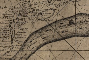
John Clive and Bernard Bailyn, “England’s Cultural Provinces: Scotland and America,” in The William and Mary Quarterly, vol. 11, no. 2, Scotland and America (Apr., 1954): 200-213.
Louis de Vorsey, “Pioneer Charting of the Gulf Stream: The Contributions of Benjamin Franklin and William Gerard De Brahm,” in Imago Mundi, vol. 28 (1976): 105-120.
Philip L. Richardson, “Benjamin Franklin and Timothy Folger’s First Printed Chart of the Gulf Stream,” in Science, New Series, vol. 207, no. 4431 (Feb., 1980): 643-645.
http://benfranklin300.org/frankliniana/result.php?id=361&sec=1
longstreet.typepad.com/thesciencebookstore/2015/06/the-gulf-stream-in-1668.html
——————————————–
Systematic observations in the Gulf Stream were begun in 1845 by Coast Survey superintendent Alexander Dallas Bache, Franklin’s grandson. Matthew Fontaine Maury’s The Physical Geography of the Sea (1855) is frequently described as the first textbook on modern oceanography. In it, Maury describes the Gulf Stream thus:
There is a river in the ocean. In the severest droughts it never fails, and in the mightiest floods it never overflows. Its banks and its bottom are of cold water, while its current is of warm. The Gulf of Mexico is its fountain, and its mouth is in the Arctic Seas. It is the Gulf Stream. There is in the world no other such majestic flow of waters.
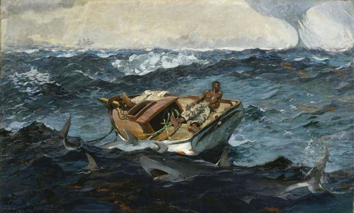
Winslow Homer, The Gulf Stream (1899), Metropolitan Museum of Art
